Generate maps for the MC2 backend
Introduction
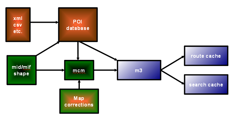
Maps can be created from any supplier delivering map data in shape or midmif map format. Shape data needs to be converted to midmif as a first step. The supplier midmif data is then converted to Wayfinder midmif format, from which mcm maps are created. POI data from the supplier is imported into the POI database, and added to the mcm maps during map generation. To fix problems in the maps, map corrections can be added to the mcm maps. Finally the mcm maps are converted to the m3 map format that is used in the MC2 back-end.
The supplier map data need to meet some requirements for location based services in order to be really good as material for the MC2 back-end server. There are different requirements for searching, routing, navigation and map display.
You will need binaries and scripts from the MC2 repo. For dealing with shape data you need a software which can display the shape files, do some simple selections and editing, and convert from shape to midmif.
The map generation scripts are generalized to handle map generation from different suppliers/countries/map releases, so you need to set up a genfiles structure for everything to work. It is a bit time consuming getting everything into place in the structure, but once you have done it, it is easy to fill in with more countries and map releases.
The process for the map conversion is described using OpenStreetMap shape map data from Geofabrik from May 2010 as an example. Additional examples for Tele Atlas MultiNet shape data map release 2010.06 are also provided.
Task list for map conversion
This is what needs to be done to produce maps for the MC2 back-end server (in this order):
- Get supplier map data in midmif format
- Convert the supplier midmif to Wayfinder midmif format
- Run individual country first generation
- Test the first generation
- Add supplier POI data to the WASP database
- Migrate map corrections from previous map release so they fit the new release
- Run individual country second generation
- Test the second generation
- Run a merge map generation combining maps from several countries second map generations
- Test the merge map generation
Prepare genfiles structure, setting files
Create the BASEGENFILESPATH genfiles with its sub directories. BASEGENFILESPATH genfiles is the base directory where all setting files for the map generation are stored. All map generation scripts that has the BASEGENFILESPATH defined need to be updated to point to the full path of where you create the BASEGENFILESPATH.
- All hosts used in map generation need to have access to the
BASEGENFILESPATH. - It is a good idea to have the
BASEGENFILESPATHon storage that is backed up or preferably version controlled separately.
Directort structure of `BASEGENFILESPATH´
genfiles/countries
genfiles/countrypol
genfiles/extradata/stitching
genfiles/mergeWorld
genfiles/script
genfiles/xml
With the following content:
genfiles/countries
Country directories with country specific setting files for the different map releases that are available for the country. The name of the country directories for the 227 countries in Wayfinder world are defined in the makemaps.mcgen wf_world countrySet list. (Antarctica is a possible country, however not wanted in the maps on Wayfinder server)genfiles/countrypol
Country polygon border break point file.genfiles/extradata/stitching
Files for stitching between countries from different map suppliers to fill gaps in the street network.genfiles/mergeWorld
Setting files for merge map generations.genfiles/script(with sub dir genfiles/script/perllib)
Directory with all sub scripts and Wayfinder Perl modules needed in map generation and POI handling, typically scripts that are located in mc2 repoServer/bin/Scripts/MapGenwith addition to some other scripts fromServer/binandServer/bin/Scripts. We have this script dir, so we can run main scripts from any directory and have all the subs in a static place. Recommended is to set up some routine that makes sure that the scripts and Perl modules are up-to-date in this dir.
All map generation scripts from the mc2 repo that refers to theBASEGENFILESPATH/script, or includes perl modules fromBASEGENFILESPATH/script/perllibvia ´use lib, need to be updated to point to the full path of where you created theBASEGENFILESPATH`.genfiles/xml
Directory with global xml setting files for map generation.
Structure in genfiles/countries, example for one country (Denmark) with one specific map release OSM_201005 (OpenStreetMap data from May 2010)
genfiles/countries/denmark
genfiles/countries/denmark/countrypol
genfiles/countries/denmark/mapssicoords
genfiles/countries/denmark/OSM_201005
genfiles/countries/denmark/OSM_201005/areafiles
genfiles/countries/denmark/OSM_201005/xml
genfiles/countries/denmark/script
With the following content:
genfiles/countries/denmark
The countries dir for Denmark, the country name as defined in themakemaps.mcgen wf_world countrySetlistgenfiles/countries/denmark/script
Setting files for map generation defining where to find map data, the name of the maps to be created for the country, and some other params needed in map generation.genfiles/countries/denmark/countrypol
The country polygon mif file, containing geometry for the land areas of the country (mainland and islands)genfiles/countries/denmark/mapssicoords
Map release specific files with mapssi coordinates which typically are used when stitching in a merge map generation. It is a text file (one for each map release) listing for each needed mcm map (decimal id) a mc2 coordinate (lat,lon) that is on a large street segment (within 2 meters from the street segment).genfiles/countries/denmark/OSM_201005
The country map release directorygenfiles/countries/denmark/OSM_201005/areafiles
Areafiles, i.e. map division files for the map release. Defines which mcm maps that will be generated and which municipals that are part of each mcm map.genfiles/countries/denmark/OSM_201005/xml
Xml files for the map release, with info about the map hierarchy and name of the country in different languages
The scripts adminworld.pl and maps_arXMLupdate.pl can be used to create the genfiles/countries structure for many countries at the same time, and also create some of the setting files needed in the genfiles country structure.
So, a summary for doing the first setup of the genfiles structure:
- Create
BASEGENFILESPATHgenfiles somewhere, preferably a git repo or similar - Create the sub dirs of
BASEGENFILESPATH - Add the
PerlTools.pmperl module togenfiles/script/perllib - Go to the
BASEGENFILESPATH/countriesdirectory and run theadminworld.plto create all the countriesadminworld.pl -m createCountryDirs -v OSM_201005 |& tee adminworld_createCountryDirs.log- The
-voption specifies the name of the country map release directory - You need to update the
use libstatement inadminworld.plto point to theBASEGENFILESPATH/script/perllibso the script can find the required perl module.
Get supplier map data in midmif format
Suggested to store the supplier data in a country folder in SUPPLIERRELEASEDIR OSM_21005. If shape data store it in eg OSM_201005/shape/DK, if midmif data store it in OSM_201005/midmif/DK.
Get OpenStreetMap shape data
OpenStreetMap maps in shape can be found eg at Geofabrik and Cloudmade. From those, thegofabrik style is the better one for creating maps for Wayfinder server.
Download OpenStreetMap shape files from Geofabrik and store in a shape country folder in SUPPLIERRELEASEDIR like OSM_201005/shape/DK (where DK is Denmark).
These are the shape files that are available from Geofabrik, and the OSM attributes available in each of the files:
buildings.shp(osmid, name, type)natural.shp(osmid, name, type)places.shp(osmid, name, type, population)points.shp(osmid, timestamp, name, type)railways.shp(osmid, name, type)roads.shp(osmid, name, ref, type, oneway, bridge, maxspeed)waterways.shp(osmid, name, type, width)
This Geofabrik OSM map data is not optimal as source for maps in Wayfinder server for several reasons. There are no administrative areas which means that we will have a very poor search index in the maps. The street network is not topologically correct, eg street segments are not split in crossings with shared nodes. Not all features and attributes from OSM data are included, eg residential areas, airport grounds and runways, golf courses, cemetery, and industrial areas are missing. A special note for Sweden is that the the big lake Vänern is missing.
Get Tele Atlas MultiNet shape data
Small samples from the Tele Atlas MultiNet Europe 20010.06 map release are available on the [wayfinder.org](http://wayfinder.org] site. It is samples for central Paris in France and Skåne in south of Sweden. Store the data in a shape country folder in SUPPLIERRELEASEDIR eg TeleAtlas/2010_06_eu_shp/shape/FR (where FR is France).
If you want other areas, complete countries etc, please contact a Tele Atlas sales office. Start at www.tomtom.com
Get shape data for country polygons
Data for the country polygon for one country is preferably taken from the same supplier that is providing the map data for that country. In that way the coastal line fits the maps data, and we don’t end up with street segments etc “in the ocean” which happens if the country polygon does not match the map data.
Country polygons for OSM map data
The OpenStreetMap data from Geofabrik does not contain any area features that can be used as country polygons, so we need to take other action.
Combine the OSM map data with country polygons from world borders shape data. It can be found for download at Thematic Mapping or from Mapping Hacks.
- Get the
TM_WORLD_BORDERS-0.2.zip(or 0.3 or whatever version is available). The key things to consider:- Pick the most detailed world borders you can find.
- In the shape file each country must be represented with only one shape feature, else you need to merge.
This world border map data is very generalized and parts of the map data from Geofabrik OSM are outside the country polygons.
Country polygons for Tele Atlas map data
For complete countries, you follow the instructions in the country polygon section. To create a country polygon before the first map generation, you can merge any of the orderX areas (eg order8 or order1) and subtract ocean waters.
For partial countries, try to use the world borders shape data. If your Tele Atlas data is inside the country, like the Paris sample, the rough world borders shape data country polygon will work. If your Tele Atlas data is a coastal area, like the Skåne south Sweden sample, you would need to combine the rough world borders shape data with the Tele Atlas orderX areas to get a nice country polygon that fits the map data.
Convert the supplier shape data to midmif
Convert thegofabrik OSM and Tele Atlas shape files to midmif (MapInfo Interchange Format) and store in a midmif country folder in SUPPLIERRELEASEDIR eg:
- for OSM maps
OSM_201005/midmif/DK(DK = DenmarkCC_CODE= the alpha2 ISO country code of the country) - for Tele Atlas maps
TeleAtlas/2010_06_eu_shp/midmif/FR- Tele Atlas MultiNet shape has many files, convert only the ones you need in conversion to Wayfinder midmif and further on in map generation.
Convert the country polygons to midmif files, with one country per file.
Convert the supplier midmif data to Wayfinder midmif
Supplier midmif is converted to Wayfinder midmif with a set of midmif parse scripts and a parse variable file with settings. The POIs from the supplier are written to a Wayfinder CPIF file.
Set up and fill parts of the genfiles structure
These sub scripts and Perl modules need to be in place in the genfiles structure for the conversion to Wayfinder midmif format:
genfiles/scriptmfunctionsmlog
- genfiles/script/perllib`
GDFPoiFeatureCodes.pmPerlCategoriesObject.pmPerlCountryCodes.pmPOIObject.pmPerlTools.pmPerlWASPTools.pm
Edit the mfunctions and mlog:
BASEGENFILESPATHto point to the full path of the genfilesTEMPLOGFILEPATH` to point to a dir where temp log files can be written
Edit PerlWASPTools.pm and define the POI SQL database settings dbname, dbhost, dbuser and dbpw in the db_connect() function for connecting to the WASP database.
Define the parse variable file
The parse variable file, named eg ‘parseMidMif_OSM_201005.sh’ can be put in the genfiles country structuregenfiles/countries/COUNTRY/script/parseMidMif_MAPRELEASE.sh ie genfiles/countries/denmark/script/parseMidMif_OSM_201005.sh. It defines where to find the supplier midmif data, which country it is, which files to use in the conversion and if there are any supplier midmif files that have Pline Multiple mif features which must be resolved (because Wayfinder map generation cannot handle it). The CC_CODE is the alpha2 ISO country code of the country.
Example of the parse variable file for OSM Denmark:
# Define OSM data directories and file names
CC_CODE="DK";
RELEASEDIR="fullpath/OSM_201005";
MIDMIFDIR="${RELEASEDIR}/midmif/${CC_CODE}";
# normal items
NETWORKMID="${MIDMIFDIR}/roads.mid";
NETWORKMIF="${MIDMIFDIR}/roads.mif";
RAILWAYMID="${MIDMIFDIR}/railways.mid";
RAILWAYMIF="${MIDMIFDIR}/railways.mif";
NATURALSMID="${MIDMIFDIR}/natural.mid";
NATURALSMIF="${MIDMIFDIR}/natural.mif";
WATERWAYSMID="${MIDMIFDIR}/waterways.mid";
WATERWAYSMIF="${MIDMIFDIR}/waterways.mif";
BUILDINGSMID="${MIDMIFDIR}/buildings.mid";
BUILDINGSMIF="${MIDMIFDIR}/buildings.mif";
# pois
CITYCENTREMID="${MIDMIFDIR}/places.mid";
CITYCENTREMIF="${MIDMIFDIR}/places.mif";
POIMID="${MIDMIFDIR}/points.mid";
POIMIF="${MIDMIFDIR}/points.mif";
# grep for Pline Multiple in mif files
#PLINEMULTIPLES="";
Example of the parse variable file for Tele Atlas MultiNet shape data, the small Paris sample in France:
# Define directories and file names
RELEASEDIR="fullpath/TeleAtlas/2010_06_eu_shp";
CC_CODE="FR";
TACC_CODE="F2075";
TACC_CODES="f2075";
MIDMIFDIR="${RELEASEDIR}/midmif/$CC_CODE";

# normal items
ADMINALTNAMES="${MIDMIFDIR}/${TACC_CODES}_an.txt";
MUNICIPALMID="${MIDMIFDIR}/${TACC_CODE}_A8.MID";
MUNICIPALMIF="${MIDMIFDIR}/${TACC_CODE}_A8.MIF";
BUAMID="${MIDMIFDIR}/${TACC_CODE}_BU.MID";
BUAMIF="${MIDMIFDIR}/${TACC_CODE}_BU.MIF";
CITYPARTMID="${MIDMIFDIR}/${TACC_CODE}_A9.MID";
CITYPARTMIF="${MIDMIFDIR}/${TACC_CODE}_A9.MIF";

MANOUVERS="${MIDMIFDIR}/${TACC_CODE}_MN.MID";
MANOUVERSPATH="${MIDMIFDIR}/${TACC_CODES}_mp.txt";
NETWORKMID="${MIDMIFDIR}/${TACC_CODE}_NW.MID";
NETWORKMIF="${MIDMIFDIR}/${TACC_CODE}_NW.MIF";
ELEMINAREA="${MIDMIFDIR}/${TACC_CODES}_ta.txt";

LANDCOVERMID="${MIDMIFDIR}/${TACC_CODE}_LC.MID";
LANDCOVERMIF="${MIDMIFDIR}/${TACC_CODE}_LC.MIF";
LANDUSEMID="${MIDMIFDIR}/${TACC_CODE}_LU.MID";
LANDUSEMIF="${MIDMIFDIR}/${TACC_CODE}_LU.MIF";
RAILWAYMID="${MIDMIFDIR}/${TACC_CODE}_RR.MID";
RAILWAYMIF="${MIDMIFDIR}/${TACC_CODE}_RR.MIF";
WATERAREAMID="${MIDMIFDIR}/${TACC_CODE}_WA.MID";
WATERAREAMIF="${MIDMIFDIR}/${TACC_CODE}_WA.MIF";
WATERLINEMID="${MIDMIFDIR}/${TACC_CODE}_WL.MID";
WATERLINEMIF="${MIDMIFDIR}/${TACC_CODE}_WL.MIF";

# pois
CITYCENTREMID="${MIDMIFDIR}/${TACC_CODE}_SM.MID";
CITYCENTREMIF="${MIDMIFDIR}/${TACC_CODE}_SM.MIF";
POIMID="${MIDMIFDIR}/${TACC_CODE}_PI.MID";
POIMIF="${MIDMIFDIR}/${TACC_CODE}_PI.MIF";
PIEA="${MIDMIFDIR}/${TACC_CODES}_piea.txt";

# grep for Pline Multiple in mif files
#PLINEMULTIPLES="";
Run the parse script
Create a parse directory where to run the conversion from supplier midmif to Wayfinder midmif, in SUPPLIERRELEASEDIR eg OSM_201005/parse. Get the needed parse scripts:
- OSM
- The autoparse script
midmif_autoParseToWF, the OSM parse scriptmidmif_osm2wayfinder.plandmidmif_fixPlineMultiple.pl.
- The autoparse script
- Tele Atlas shape
- The autoparse script
midmif_autoParseToWF, the TA parse scriptmidmif_taMNshape2wayfinder.plandmidmif_fixPlineMultiple.pl.
- The autoparse script
Then edit:
midmif_autoParseToWFUpdateBASEGENFILESPATHfor pointing to mfunctions. If parsing a new release, add the release- The supplier parse script
midmif_osm2wayfinder.pland/ormidmif_taMNshape2wayfinder.pl:- For OSM only, define language
$m_langStrfor the country$opt_cin parsing of the-loption (missing $opt_l), and the WASP database language id (since OSM does not provide name language for name strings) - Change the
use libstatement to include Perl modules in theBASEGENFILESPATH/script/perllib - If parsing a new release, add the release and column order of all types to the script (else it will die)
- For OSM only, define language
Run the conversion in 5 steps, with the midmif_autoParseToWF script:
OSM
   ./midmif_autoParseToWF -mapRelease OSM_201005 -coordSys wgs84_latlon_deg
   -parseVarFilegnfiles/countries/denmark/script/parseMidMif_OSM_201005.sh
   -start 1 -stop 1
   |& genfiles/script/mlog step1_gf_dk
Tele Atlas
   ./midmif_autoParseToWF -mapRelease TA_2010_06 -coordSys wgs84_lonlat_deg
   -parseVarFile fullPath/genfiles/countries/france/script/parseMidMif_TA_2010_06.sh
   -start 1 -stop 1
   |& genfiles/script/mlog step1_ta_fr
Continue with step 2, 3 and 4 (change the -start and -stop options) to prepare for and to parse the normal items. Then run step 5 to parse the POIs.
If step 4 (normal items) or 5 (POIs) dies, read the logfile of the type that was parsed wf_midmif/DK/create/logpath/parse_type.log and fix the problem in the supplier parse script (midmif_osm2wayfinder.pl or midmif_taMNshape2wayfinder.pl respectively). Then run the step again, until everything is parsed without exits.
The auto-parse script step 4 creates the Wayfinder WF midmif files in a wf_midmif country folder in SUPPLIERRELEASEDIR eg OSM_201005/wf_midmif/DK/create and TeleAtlas/2010_06_eu_shp/wf_midmif/FR/create
The auto-parse script step 5 creates a Wayfinder CPIF file (Wayfinder complex POI import format) with POIs to be added to the POI database. It is created in a sub directory to the wf_midmif country folder, eg OSM_201005/wf_midmif/DK/poi and for Tele Atlas TeleAtlas/2010_06_eu_shp/wf_midmif/FR/poi
For step 5, parsing POIs, there is room for improvements especially for parsing OSM POI types to Wayfinder POI types. A lot of OSM POI types are currently set to non-existing Wayfinder POI type -1 which means that those POIs will not be included in the resulting POI import file.
These are the step 4 Wayfinder midmif item files to use in map generation. It is ok for the files to be empty (mif files only containing the mif header). Note the name of the item files. The midmif items will be added to the mcm maps from the files in alphabetical order.
OSM
  WFferryItems.mid/mif
  WFforestItems.mid/mif
  WFindividualBuildingItems.mid/mif
  WFparkItems.mid/mif
  WFrailwayItems.mid/mif
  WFstreetSegmentItems.mid/mif
  WFstreetSegmentItemsturntable.txt
  WFwaterItems_all.mid/mif
Tele Atlas
   areaWFbuiltUpAreaItems.mid/mif
   areaWFcityPartItems.mid/mif
   WFaircraftRoadItems.mid/mif
   WFairportItems.mid/mif
   WFbuildingItems.mid/mif
   WFcartographicItems.mid/mif
   WFferryItems.mid/mif
   WFforestItems.mid/mif
   WFindividualBuildingItems.mid/mif
   WFislandItems.mid/mif
   WFparkItems.mid/mif
   WFrailwayItems.mid/mif
   WFstreetSegmentItems.mid/mif
   WFstreetSegmentItemsturntable.txt
   WFwaterItems_all.mid/mif
Move them to the MAPPATH in map generation (defined in the variable file), which is wf_midmif/DK and wf_midmif/FR respectively. Do clean up according to instructions from the step 4, eg:
- remove any crap from the end of WF mif files (cosmetic mif features)
- make sure that the
CoordSystag is one that map generation can read, egwgs84_latlon_degorwgs84_lonlat_deg. SeegSGfxData::readMifHeader()for all available coord sys strings.
Create the midmif areafiles from Wayfinder municipal midmif file
The so called midmif areafiles are required for map generation from WF midmif. They are used for initializing the maps, i.e. decides thegographic extent of each of the mcm map. So the input for the WF municipal midmif files needs to be covering all of the country land area (mainland and islands). It is perfectly OK if they also cover coastal ocean areas and/or areas between islands as long as those areas are part of the country’s territory (territory = it must not overlap areas covered by another country’s midmif areafiles. In this way also street segments that are part of bridges between mainland and/or islands will be inside the mcm map, which is really good in the map generation.
The name of the midmif areafiles is SOMETHING_municipalItems. The municipalItems is required for the map generation to detect which type of item to create from the midmif file, in this case municipals. See ItemTypes::getItemTypeFromString to find the strings for all item types. The structure of SOMETHING is COUNTRYCODE_someName. The COUNTRYCODE is the same as is specified in the variable file, the setting file for country map generation. The someName part of the name should be descriptive for the content of the areafile. If having only one map in the country a good name would be eg dk_whole_municipalItems. The name of the resulting mcm map will be COUNTRYCODE_someName, parsing the midmif areafile name to define the mcm map name is done in the makemaps script.
Ideally there would be administrative areas data from the map supplier resulting in a WF municipal midmif file with all municipals in the country. Move or copy the WF municipal mid and mif file to the muncipal directory in wf_midmif/DK/municipal.
Create WF municipal files for OSM maps from the world_boundry data
There are no administrative areas from Geofabrik OSM shape files, so the best thing to do is to use the country from the world_boundry shape file.
From the world_boundry shape file, select the country/countries you are interested in. Convert each country to midmif and use it as the WF municipal midmif file. Each country must have a midmif file of its own; denmark.mid/mif, sweden.mid/mif.
Edit the country mid file to have the structure of a WF municipal mid file, eg for Denmark change:
"DA","DK","DNK",208,"Denmark",4243,5416945,150,154,9.264,56.058  1. >
208,"Denmark","Denmark:officialName:eg
and for Sweden
"SW","SE","SWE",752,"Sweden",41033,9038049,150,154,15.270,62.011  1. >
752,"Sweden","Sweden::officialName:eg
Create the midmif areafiles for OSM maps
Create a working directory for the areaUpdate eg OSM_201005/areaUpdateDK. Copy the script midmif_areaFilesNewRelease and copy or at least locate where to find the MifTool binary.
Use the WF municipal midmif file with all municipals from the country. For thegofabrik OSM data, use the edited world_boundry country midmif file.
If possible create a file mapDivision.txt in the areaUpdate directory. The mapDivision.txt is deciding which municipals to include in which midmif municipal areafile, i.e. which municipals should be in which mcm map when running individual country map generation for the country. Each line of the mapDivision.txt holds “midmifAreafileName municipalID”, eg for the municipal with ID 208 to end up in the areafile dk_whole_municipalItems dk_whole_municipalItems 208
Then run the midmif_areaFilesNewRelease script.
In the full run midmif_areaFilesNewRelease can create a mapDivision.txt file from previous map release to re-use the map division for the new (current) map release. This can only be used if you have an old release of the current one and municipal IDs are stable over the release versions.
./midmif_areaFilesNewRelease
-oldReleaseDir genfiles/countries/denmark/OSM_201002
-munMidFile OSM_201005/wf_midmif/DK/municipals/denmark.mid
-munMifFile OSM_201005/wf_midmif/DK/municipals/denmark.mif
-varFilegnfiles/countries/denmark/script/variables_denmark.OSM_201002.sh
-mifTool binDir/MifTool
|& genfiles/script/mlog areaUpdateFull
If you created the mapDivision.txt manually, run with the -onlyCreateMidMifAreaFiles option
./midmif_areaFilesNewRelease
-onlyCreateMidMifAreaFiles
-oldReleaseDir XXX
-munMidFile OSM_201005/wf_midmif/DK/municipals/denmark.mid
-munMifFile OSM_201005/wf_midmif/DK/municipals/denmark.mif
-mifTool binDir/MifTool
-varFile XXX
|& genfiles/script/mlog areaUpdateShort_dk
This results in the midmif areafiles
dk_whole_municipalItemsmap.mifdk_whole_municipalItems.mifdk_whole_municipalItems.mid
Move these areafiles to the genfiles country map release areafiles dir eg genfiles/countries/denmark/OSM_201005/areafiles.
Create the midmif areafiles for Tele Atlas Paris maps
This was an easy case, since we have only one municipal (from the Tele Atlas order 8 feature) in the Paris sample. And With only one municipal in the midmif areafile, the map.mif file equal to the .mif file.
- rename the
WFmunicipalItems.mid/miftofr_centralparis_municipalItems.mid/mif - copy the
fr_centralparis_municipalItems.miftofr_centralparis_municipalItemsmap.mif
Move these areafiles to the genfiles country map release areafiles dir eg genfiles/countries/france/TA_2010_06/areafiles
Create the midmif areafiles for generic maps
If it is a large country, the country need to be split in more than one map, else the mcm maps in the map generation will be too large to handle. The limit for large can be approx more than 500000 street segments or whatever limit you find out that your system has. It does not only depend on number of street segments but also how many other item types you have in your maps.
If you have several municipals from the map supplier in the WF municipal item file, simply put the municipals in different midmif areafiles by specifying different midmifAreafileName for the municipal IDs in the mapDivision.txt. One midmif areafile will be one mcm map, it is OK to have many municipals in one midmif areafile. If splitting into many areafiles, try to keep neighboring municipals in the same areafile and try to give the areafiles a descriptive name eg west part of the country in dk_west_municipalItems and east part of the country in dk_east_municipalItems. See the OSM example above for howto run the midmif_areaFilesNewRelease script.
If you only have one municipal from the map supplier for a large country, eg as for thegofabrik OSM data case, you need to be creative. One option is to split the country shape file in several parts (as many as you need to havegod mcm map sizes). Each part must then have unique ID in the WF municipal item mid file. It is OK if they still all have the same name Denmark.
In countries with more than one mcm maps, the midmif items are added to the correct map based on geometry or via settlement ids. Geometry will not always work to get eg large bridge street segments and ferry lines into a mcm map. If the supplier map data does not provide information for settlementID, like thegofabrik OSM data, then you need to be creative again and find a way to define settlement ids for street segments pointing at the municipal ids of the mcm map where you want the street segments to be added.
Suggestions on things to improve in the supplier parse scripts
For Tele Atlas, the parse script midmif_taMNshape2wayfinder.pl can be improved to add more things that are supported by the Wayfinder midmif format and CPIF file. These are marked with uppercase fixme in the parse script.
- house numbers to the street segments file in the
handleNetworkFile()method - zip codes to the street segment file in the
handleNetworkFile()method - use more attributes from the PIEA file for POIs, in
thegtInfoStringForPIEA()method. It concerns eg the BQ bus stop type attribute, to decide whether a bus stop POI is really a bus stop or a bus terminal (change the POI type) - improve handling of maneuvers in the
handleRestrictions()method for maneuvers that are marked with handledOK=0. That marks that something needs change to handle all entries from the maneuvers file properly.
For OpenStreetMap, the parse script midmif_osm2wayfinder.pl can be improved:
- The
initPOITypesHash()method maps the OSM POI types to Wayfinder POI types. A lot of OSM POI types are currently set to non-existing Wayfinder POI type -1 which means that those POIs will not be included in the resulting POI import file. To include more POIs in the CPIF, define appropriate Wayfinder POI type id for them. - Add more OSM types to the types2wfcat hash if appropriate to set specific Wayfinder POI category for them. Needs to be set if the Wayfinder POI type is not enough to set a good category using the mapping defined in the WASP POICategoryTypes table.
Prepare for individual country map generation
An individual country generation creates maps from the supplier map data, for one country.
The result of an individual country generation should not be added to a MC2 back-end production server. Some necessary info is not added in the country generation, so you need to do a merge map generation of your countries to get maps for the MC2 back-end production server.
Scripts in the genfiles structure
Additional scripts used in individual country map generation in
genfiles/script(don’t forget to updateBASEGENFILESPATHto point to the full path of the genfiles)extradata.shmaps_countryInfo.plfiltermergedMaps.sh
Setting files in the genfiles structure
Additional setting files used in individual country map generation in
* genfiles/xml * region_ids.xml (from Server/bin/Scripts) * map_generation-mc2.dtd (from Server/bin)
Setting files in the genfiles country structure
Additional setting files needed in the genfiles country structure.
Set up the genfiles country structure, populate the setting files that is needed for individual country generation. Remember that the structure and some setting files can be created for all countries with the scripts adminworld.pl and maps_arXMLupdate.pl.
genfiles/countries/denmarkgenfiles/countries/denmark/scriptvariables_denmark.OSM_201005.sh- variable file = setting file for map generation eg defining MAPPATH = where to find Wayfinder midmif map data, the name of the maps to be created for the country, and some other params needed in map generation.
- For Denmark and Sweden from OSM Geofabrik files I specify the
ONLYONEMAPparameter, which will force all items from the midmif files of the country to be added to the one and only mcm map.- positive: all items added to the one mcm map, else missing roads ets.
- negative: location will not be set for items outside the admin areas
- specially need to consider using this attribute for coastal countries
- Generic variable files can be created for many countries at the same time with the
adminworld.pl -m createVarFile
genfiles/countries/denmark/countrypoldenmark.mif- The country polygon mif file, containing geometry for the land of the country (mainland and islands).
- This should be as detailed as possiblegometry-wise since it is used for displaying land areas in map images. It must contain one mif Region feature only, ok to have as many polygons as is needed in the Region feature.
- There should be one country polygon mif file for each country overview map in the country, and the mif files should have the country overview map name followed by the suffix .mif. The name of the country overview map is defined in the map release co.xml file. Example in Denmark the country overview map is called denmark so the country polygon mif file is called denmark.mif. A very large country may have more than one country overview map, called eg germany_1 and germany 2, must have country polygon mif files named germany_1.mif and germany_2.mif. Both those country polygon mif files must have the exact same content, ideally let them be links to a file called germany.mif.
- (08-map)
- For faster map generation, the country overview map(s) for the country from a “whole-world” merge map generation.
- The filtering of the country polygon, i.e. the country overview map gfxData is copied from the old country overview map in countrypoldirectory, so map generation can skip the rather time consuming step of filtering of the country polygon. Filtering = remove un-necessary coordinates and pre-store 16 filtering levels in the countrypolygon for fast access of a good filtering level when displaying the country in a map image of any zoom level.
- Reason for the 08-map must come from a world merge map generation is that neighboring countries must have been filtered together so that the country border parts have the exact samegometry to avoid gaps when displaying the country in a map image. Related: see mfunctions
countryOrder(),PerlCountryCodes.pm::countryOrdervector to see in which order the countries are processed in a merge map generation, i.e. which country border geometry is re-used for the next country.
genfiles/countries/denmark/OSM_201005- the map release directory
genfiles/countries/denmark/OSM_201005/areafiles- Contains the midmif areafiles, i.e. map division files for the map release. Defines which mcm maps that will be generated and which municipals that are part of each mcm map.
- One midmif areafile consists of .mid .mif and map.mif files. The .mid and .mif file contains the municipal items to add to the mcm map that is created from the areafile. The municipals are stored according to Wayfinder midmif format. The map.mif file contains the outline of the municipals merged in the .mif file, and will be thegxData (thegometry) of the mcm map created from the areafile. The map gfxData is used when adding other midmif items, eg forests, parks, street segments to decide which is the the correct mcm map to add them to. The midmif items are added only if they fall within thegxData of the mcm map.
genfiles/countries/denmark/OSM_201005/xml- Contains xml files with info about the map hierarchy and name of the top region(s) of the country in all languages
map_generation-mc2.dtd- linked to theglobal
genfiles/xml/map_generation-mc2.dtd
- linked to theglobal
country_co.xmlegdenmark_co.xml- lists the map hierarchy in the country, according to the create_overviewmap XML spec in map_generation-mc2.dtd. It lists the name of the overview map(s) in overview_ident tag, and for each overview map it lists the name of the underview maps that belong to the overview with the map_ident tag. The map_ident tags may be listed in any order. The underviews are added to the overview in alphabetical order anyway.
- Example for Denmark the overview_ident (name of the overview map) is “denmark” and the underview for that is map_ident “dk_whole”.
- The
country_co.xmlis map release specific, so this denmark_co.xml is valid only for the OSM_201005 map release. Reson to why it is release specific is that map division is likely to be different if we have maps from another supplier and/or another map release from the same supplier. The co_xml file must contain the name of all underview maps of the specific map release as map_ident tags. Seemakemapsscript parsing ofmapNameto find out how the areafile name is parsed into mcm map name. Or, leave the map_ident tags blank until first steps of the individual country generation has been done, when you can use thewhichmapsscript (fromServer/bin/Scripts) to find out the name of the mcm underview map. - The co XML files can be created for many countries at the same time with the
adminworld.pl -m createCoXML
country_ar.xmlegdenmark_ar.xml- contains the info needed for setting region identity, according to the add_region XML spec in map_generation-mc2.dtd. The possible regions are defined in the
region_ids.xml(fromServer/bin/Scripts) asregion ident. - lists top region region_ident for this country, the available translations to different languages for the top region name (name language and type), and the overview map(s) that belong to this top region content map_ident as defined in co.xml file overview_ident. Example for Denmark the add_region region_ident is “denmark”, the translation for language egish officialName is “Denmark”, the translation for spanish is “Dinamarca”, and the overview maps that are part of this region is content map_ident “denmark” whole_map
- The translations can be picked from
StringTableUTF8::strings, using theStringTable::getCountryStringCode()to get the stringCode for the specific country.StringTable::countryCodeis extracted withMapGenUtil::getCountryCodeFromGmsName()when generating the map. - The add-region XML files can be created for many countries at the same time with the
maps_arXMLupdate.pl -m createArXML.
- contains the info needed for setting region identity, according to the add_region XML spec in map_generation-mc2.dtd. The possible regions are defined in the
Examples of setting files in the genfiles country structure
Example of variable file
Example of the genfiles/countries/denmark/script/variables_denmark.OSM_201005.sh
MAPRELEASE="OSM_201005";
# Long version of the map supplier, needed in variable file
# to override makemaps default value TeleAtlas_
MAP_SUPPLIER="OpenStreetMap_"

AREAPATH="${GENFILESPATH}/${MAPRELEASE}/areafiles"
CO_CODE="dk_"

MAPPATH="fullPath/OSM_201005/wf_midmif/DK"

# Setting ONLYONEMAP means that all items in the item midmifs files will be
# forced added to the one-and-only mcm map, overriding the other available
# methods for checking correctMap (within map gfxdata, settlementId,
# map ssi coord)
ONLYONEMAP="true"

AREALIST="dk_whole_municipalItems"
Example of country polygon mif file
Example of the countries/denmark/countrypol/denmark.mif as it was created when converting the world_borders shape file to midmif.
VERSION 300
Charset "WindowsLatin1"
Delimiter ","
Coordsys wgs84_latlon_deg
Columns 11
  Fips Char (2)
  Iso2 Char (2)
  Iso3 Char (3)
  Un Decimal (3,0)
  Name Char (50)
  Area Decimal (7,0)
  Pop2005 Decimal (10,0)
  Region Decimal (3,0)
  Subregion Decimal (3,0)
  Lon Decimal (8,3)
  Lat Decimal (7,3)
Data
Region 18
  72
54.82972000 11.51388700
54.82193800 11.56444400
54.87777700 11.64250000
54.90083300 11.64166600
54.90388500 11.64194300
...
Example of midmif areafiles
Examples of the midmif areafiles for Denmark OSM_201005 map release as they were created from the world_borders shape Denmark county, converted to midmif and then edited to fit Wayfinder municipal midmif files. Finally processed with the midmif_areaFilesNewRelease script.
countries/denmark/OSM_201005/areafiles/dk_whole_municipalItems.mid with the attributes of all municipal (one) that will be added to the dk_whole mcm map in map generation.
208,"Denmark","Denmark:officialName:eg
countries/denmark/OSM_201005/areafiles/dk_whole_municipalItems.mif with thegometry of all municipal (one) that will be added to the dk_whole mcm map in map generation.
VERSION 300
Charset "WindowsLatin1"
DELIMITER ","
COORDSYS mc2
COLUMNS 3
  LOCAL_ID integer(16,0)
  NAME char(50)
  ALL_NAMES char(256)
DATA
Region 18
551
680892285 118997724
680255126 120779372
680125967 121057757
680072900 121183683
679966862 121445485
679887298 121747064
679847522 121906133
679827682 122028766
...
countries/denmark/OSM_201005/areafiles/dk_whole_municipalItemsmap.mif with thegometry of the dk_whole mcm map, i.e. the outer line of all municipals in the map. In this case, since we have only one municipal in the dk_whole areafile, the map.mif file equal to the .mif file.
VERSION 300
Charset "WindowsLatin1"
DELIMITER ","
COORDSYS mc2
COLUMNS 3
  LOCAL_ID integer(16,0)
  NAME char(50)
  ALL_NAMES char(256)
DATA
Region 18
551
680892285 118997724
680255126 120779372
680125967 121057757
680072900 121183683
679966862 121445485
679887298 121747064
679847522 121906133
679827682 122028766
...
Example of co.xml file
Example of a countries/denmark/OSM_201005/xml/denmark_co.xml file:
	<?xml version="1.0" encoding="ISO-8859-1" ?>
	<!DOCTYPE map_generation-mc2 SYSTEM "map_generation-mc2.dtd">

	<map_generation-mc2>
	   <create_overviewmap overview_ident = "denmark">
	      <map map_ident = "dk_whole"/>
	   </create_overviewmap>
	</map_generation-mc2>
Example of ar.xml file
Example of a countries/denmark/OSM_201005/xml/denmark_ar.xml file:
	<?xml version="1.0"  encoding="UTF-8"?>
	<!DOCTYPE map_generation-mc2 SYSTEM "map_generation-mc2.dtd">

	<map_generation-mc2>
	   <add_region type="country" region_ident="denmark">
	      <name language="czech" type="officialName">Dánsko</name>
	      <name language="danish" type="officialName">Danmark</name>
	      <name language="german" type="officialName">Dänemark</name>
	      <name language="greek" type="officialName">Δανία</name>
	      <name language="egish" type="officialName">Denmark</name>
	      <name language="spanish" type="officialName">Dinamarca</name>
	      <name language="finnish" type="officialName">Tanska</name>
	      <name language="french" type="officialName">Danemark</name>
	      <name language="hungarian" type="officialName">Dánia</name>
	      <name language="italian" type="officialName">Danimarca</name>
	      <name language="dutch" type="officialName">Denemarken</name>
	      <name language="norwegian" type="officialName">Danmark</name>
	      <name language="polish" type="officialName">Dania</name>
	      <name language="portuguese" type="officialName">Dinamarca</name>
	      <name language="russian" type="officialName">Дания</name>
	      <name language="slovenian" type="officialName">Danska</name>
	      <name language="swedish" type="officialName">Danmark</name>
	      <name language="turkish" type="officialName">Danimarka</name>
	      <name language="chinese" type="officialName">丹麦</name>
	      <name language="chinese_traditional" type="officialName">丹麥</name>

	      <content map_ident="denmark">
	         <whole_map/>
	      </content>
	   </add_region>
	</map_generation-mc2>
Map generation binaries
The following binaries and scripts are needed for individual country map generation. They are all found in the mc2 repo, the binaries with capital letter are build artifacts. Don’t forget to update BASEGENFILESPATH in misc scripts to point to the full path of the genfiles directory.
These are the binaries and scripts needed
makemapsfromServer/bin/Scripts/MapGen. The main script for individual country map generation.distributefrom `Server/Tools/distribute´ExtradataExtractorfromServer/MapGen/ExtradataExtractor. Needed if to apply map correction records from WASP database.GenerateMapServerfromServer/binmc2.propfromServer/bin. Set the MAP_PATH to “./” and define POI SQL database settings.QualToolfrom `Server/MapGen/QualTool? . Needed for analyse/verification of map generation as preparation for test.verifyfromServer/bin/Scripts/MapGenVerifyfromServer/MapGen/VerifyWASPExtractorfromServer/MapGen/WASPExtractor. Needed if to add POIs from WASP database.whichmapsfromServer/bin/Scripts
If generating maps from a new supplier, please add the supplier to the mc2 repo to the following files and compile new binaries. Example new supplier OpenStreetMap:
Server/Shared/include/MapGenEnums.hMapGenEnums::mapSupplier()Server/Shared/src/MC2MapGenUtil.cppMC2MapGenUtil::mapSupCopyrigthStrings()Server/MapGen/src/MapGenUtil.cppMapGenUtil::initMapSupMapping()Server/bin/Scripts/map_supplier_names.xml- Add the copyright string for the new supplier, english language. It is the copyright string that will be displayed when showing a map image over an map area that is provided by the supplier
If generating maps from a new release from a known or new supplier, please add the map release to the mc2 repo to the following files and compile new binaries. Example new release OSM_201005 from supplier OpenStreetMap:
Server/Shared/include/MapGenEnums.hMapGenEnums::mapVersion
If you plan to use the WASP database for POIs and/or map corrections, also add the map release to the WASP EDVersion table. The ID in the EDVersion table must equal the ID in theMapGenEnums::mapVersionenum. The version string in the EDVersion table must be the map release with the long version of the map supplier string, i.e. the MAP_SUPPLIER defined in the variable file, egOpenStreetMap_201005orTeleAtlas_2010_06.Server/MapGen/src/MapGenUtil.cppMapGenUtil::getMapVerFromStringServer/bin/Scripts/MapGen/makemapsparsing ofMAP_RELEASE_ARGServer/MapGen/src/NationalProperties.cpp
Verify thatNationalProperties::getMapToMC2ChEnc()gives correct char encoding for the new map supplier/release.
Run individual countries first map generation
There are two types of individual country generations, a first generation and a second generation. The first generation simply creates maps from the supplier map data (from the Wayfinder midmif files), the second generation also connects to the WASP database to add POIs and/or map corrections.
Both the first gen and the second gen can be run in single-mode country-by-country or in multi-mode with many countries at the same time.
If you have many countries it is recommended to run one country as single generation to see that you have all setting files etc in place. Then run a multi generation for the rest of the countries.
All map generations from one map release can be done in the mcm map release directory eg for OSM mcm/OSM_201005 and for Tele Atlas mcm/TA_2010_06_eu_shp.
Individual country single first generation
Run a first generation for one country from the map release
- Create a country generation directory for the map release, eg mcm/OSM_201005/dk_20100520_first
- Copy the generation binaries to it
- Run the makemaps script
./makemaps -mapRelease OSM_201005 -noExtFiltOrWASP -dist2 -afterMapDataExtrBackup denmark |& genfiles/script/mlog makemaps_denmark- The country option value is equal to the name of the country directory in genfiles/countries, see the makemaps.mcgen wf_world countrySet list for available countries.
- The
-dist2makes some steps in the map generation to be distributed on 2 processors of the localhost - The
-afterMapDataExtrBackupleaves us with a nice backup, which can be used to start the second generation. - The
-noExtFiltOrWASPis the option that defines “first generation”, it means no extradata (map corrections) from WASP database or extradata.sh, no POIs from WASP database, and no filtering of the final maps.
- The mlog creates 2 log files, one simple called
makemaps_denmark.logand one for debugmakemaps_denmark.dbg.log. Thedbg.logfile includes all commands and everything that happens and is good to read in case things crash. For all other purposes read the simple makemaps_denmark.log file.
Example for the Tele Atlas France small Paris sample:
./makemaps france -mapRelease TA_2010_06 -noExtFiltOrWASP -afterMapDataExtrBackup -dist2 |& genfiles/script/mlog makemaps_france
Multi first generation
Run first generation for several countries from one map release at the same time. This is done with the makemaps.mcgen script, which sets up and starts generation with makemaps script for all countries.
- Create a multi directory eg
mcm/OSM_201005/20100603_multiFirst_dk_se - Create the multi countries directory where the countries will be generated eg
mcm/OSM_201005/20100603_multiFirst_dk_se/countries - Create the multi generation directory where the multi generation is done eg
mcm/OSM_201005/20100603_multiFirst_dk_se/1_countries- Copy the
makemaps.mcgenscript here - Edit the
makemaps.mcgenmyCountriesCOUNTRYLISTto list all the countries you want to have in the multi generation. The first country is processed first. When one country is finished, the next country in the list is started. List the largest country first and the smallest country last inCOUNTRYLIST. That way, if you run the multi generation on more than one host (the-countryGenComputersoption), the distribution will be optimal not having to wait for a large country when all other countries are finished.
- Copy the
- Create the generation bin directory eg
mcm/OSM_201005/20100603_multiFirst_dk_se/1_countries/bin- Copy the generation binaries to it
- Goto the multi generation directory and run the makemaps.mcgen script
./makemaps.mcgen -countries myCountries -noMerge -binPath bin -countriesPath ../countries/ -mapRelease OSM_201005 -countryGenComputers "host host" -dist2 -cntrFirstGen |& /home/is/devel/Maps/genfilesPSTC/script/mlog master1_countries- The countries from myCountries COUNTRYLIST will be distributed on 2 processors on the computer named “host”. Each country is then run with -dist2, so in total 4 processors on “host” will be used.
- The
-cntrFirstGenoption tells themakemapsscript to run with-noExtFiltOrWASPand-afterMapDataExtrBackupoptions for each of the countries.
Run individual countries second map generation
The second generation of a individual country does the same thing as the first generation does, but it also connects to the WASP database to add POIs and/or map corrections. The second gen can be run in single-mode country-by-country or in multi-mode with many countries at the same time.
Individual country single second generation
Will contact WASP database for addition of POIs and apply map correction records.
- Create a country generation directory for the map release, eg
mcm/OSM_201005/dk_20100607_second - Copy the generation binaries to it (don’t forget
WASPExtractorandExtradataExtractor) - Run the makemaps script
./makemaps -mapRelease OSM_201005 -noFilt -dist2 denmark |& genfiles/script/mlog makemaps_denmark- Run with
-noFiltto skip filtering of coordinates in the maps. It is not needed in individual country generation, only necessary in merge map generation.
- If you want to save time for a large country, it is possible to re-use the
after_mapDataExtrbackup from the first generation. To make this happen add the following to the makemaps command-fromMapDataExtr -mdeBkpDir mcm/OSM_201005/dk_20100520_first/after_mapDataExtr
Example for the Tele Atlas France small Paris sample in mcm/TA_2010_06_eu_shp/fr_20100628_second:
./makemaps france -mapRelease TA_2010_06 -noFilt -dist2 |& genfiles/script/mlog makemaps_france
Multi second generation
Run second generation for several countries from one map release at the same time.
- Create the multi directory eg
mcm/OSM_201005/20100608_multiSecond_dk_se - Create the multi countries directory where the countries will be generated eg
mcm/OSM_201005/20100608_multiSecond_dk_se/countries - Create the multi generation directory where the multi generation is done eg
mcm/OSM_201005/20100608_multiSecond_dk_se/1_countries- Copy the
makemaps.mcgenscript here - Edit the
makemaps.mcgenmyCountries`COUNTRYLIST´ to list all the countries you want to have in the multi generation.
- Copy the
- Create the multi generation bin directory eg
mcm/OSM_201005/20100608_multiSecond_dk_se/1_countries/bin- Copy the generation binaries to it
- Goto the multi generation directory and run the makemaps.mcgen script
./makemaps.mcgen -countries myCountries -noMerge -binPath bin -countriesPath ../countries/ -mapRelease OSM_201005 -countryGenComputers “host host” -dist2 & /home/is/devel/Maps/genfilesPSTC/script/mlog master1_countries - The countries from myCountries COUNTRYLIST will be distributed on 2 processors on the computer named “host”. Each country is then run with -dist2, so in total 4 processors on “host” will be used.
- The makemaps script will be started with -noFilt by default.
- If you want to re-use the
after_mapDataExtrbackup from the first generation of some/all countries, you need to edit the makemaps.mcgen script hardcoding themdeBkp(search for mdeBkp to find the place).
Test the individual countries map generation
Verification of mcm maps
Verify the individual country generation with the following actions
- Check that the log from the makemaps script ends with “Finished country”
- (Read the qualLog/qualityreport.log). This is an old verification method, and not very informative, it sometimes reports errors that are not errors.
- Run a
qualDiffcomparing the generation with maps from the previous map release or a previous map generation of the same release.- Create and goto a diff-dir in the country directory, where you run the
maps_genQualityCheckscript. - Example for comparing the OSM_201005 first generation with the first generation of the previous map release OSM_201002. To see the differences in map data reflecting the updates the supplier has done in the new map release.
- go to
mcm/OSM_201005/dk_20100520_first/diff_2_OSM_201002_first ./maps_genQualityCheck -bin .. mcm/OSM_201002/dk_20100215_first .. |& teegnQualCheck.log
- go to
- Example for comparing the OSM_201005 second generation with the OSM_201005 first generation. To see what differences wegt with POIs and map corrections
- go to
mcm/OSM_201005/dk_20100607_second/diff_2_first ./maps_genQualityCheck -bin .. mcm/OSM_201005/dk_20100520_first .. |& teegnQualCheck.log
- go to
- The script uses the
QualToolbinary to calculate some statistics for the maps so you can see increases and decreases in the maps. Statistics for theFIRSTMAPSis written to the1_[]_MapsQual.logand theSECONDMAPSis written to the2_[]_MapsQual.log. These termsFIRSTMAPS+SECONDMAPSare only a description of the order in which maps are pointed to by the options of themaps_genQualityCheckscripts, not a reference to either first or second generation. All differences between first and second maps are written to the[..]_MapsQualDiff.logfile, the important subset of the diffs is written to the[]_ShortMapsQualDiff.logfile. If the diff-files are very large, you can use the ``maps_mcmAnalyseQual` script to list only increases/decreases larger than certain number or percentage.
- Create and goto a diff-dir in the country directory, where you run the
- Check that all items from the Wayfinder midmif files were added to the mcm maps. Check the makemaps log file “Adding mid/mif items:”. Look for the lines saying “Adding from WFforestItems” followed by “added 3234 of 3234”. If not all the available items were added to the mcm maps, it is possible to analyze which items were missing. Especially street segments are important that all were added, if you plan on using the maps for navigation. Remember, if the items are added to mcm maps based on geometry, the first coordinate in the item’s gfxData must be inside a mcm map gfxData for it to be added.
midmif_tool.plcan help you list which items were not added to the mcm maps. Run it with option-w, example:./midmif_tool.pl -w OSM_201005/wf_midmif/DK/WFstreetSegmentItems.mid OSM_201005/wf_midmif/DK/WFstreetSegmentItems.mif mcm/OSM_201005/dk_20100520_first/logpath/create_WFstreetSegmentItems.log |& tee listNotAddedMidItems.log- Result presents the midId, midRow, name (if any) and one coordinate of the not added items.
- If there are any important items missing, find all coordinates of the item with
CoordConvert -i MIDROW WFstreetSegmentItems.mif - If there are many items missing one approach is to save a file with a list of all first coordinates and view the coordinates in MapEditor with
--highlightCoordsoption. The coordinates must be mc2 to load. Example convert a file with wgs84_deg coords to mc2 coords.CoordConvert --convertTextFile --inFormat=wgs84_deg --outFormat=mc2 --latPos=2 --lonPos=1 --outCoordinateOrder=latlon --fileSep=" " --saveAs=mc2Coords.txt notAdded_water_coords.log
For a multi first or a multi second generation you can use the maps_multiReleaseTasks.pl script to generate qualDiff for all countries at the same time. For the multi first generation use option -diffFirstToFirst, comparing the map release first generation with the first generation of the previous map release. For the multi second generation use option -diffSecondToFirst, comparing the second generation with the first generation of this map release.
- Goto the mcm map release directory e
g mcm/OSM_201005 - Update
maps_multiReleaseTasks.plBASEGENFILESPATHto point to the full path of the genfiles and theuse libstatement. - Run the
maps_multiReleaseTasks.pl. It expects to find themaps_genQualityCheckandmaps_mcmAnalyseQualscripts in theBASEGENFILESPATH/scriptdirectory.maps_multiReleaseTasks.pl -diffFirstToFirst -prevBaseDir mcm/OSM_201002 -mcmBaseDir mcm/OSM_201005 -binDir mcm/OSM_201005/dk_20100520_first sweden denmark |& tee multiFirstDiff2first_dk_se.log- the country names in tail given as defined in the makemaps.mcgen wf_world countrySet list
-binDircan point to any directory where there is aQualToolbinary to use.
- The script has an automatic routine to find the country generation directories to compare (in this case the
mcm/OSM_201002/dk_20100215_firstandmcm/OSM_201005/20100603_multiFirst_dk_se/countries/denmark). It runs a find command in the prevBaseDir and the mcmBaseDir respectively and finds directories that contain the word “first” (not case sensitive) for first generations and either the alpha2 ISO country code of the country or the whole country name (as given in tail to the script). The dk_20100215_first in OSM_201002 is found because the dir name contains “dk_” and “first”. The 20100603_multiFirst_dk_se/countries/denmark in OSM_201005 is found because the dir name is “denmark” and it is located in a dir containing “First”. If several candidate dirs are found, the script prompts you to decide which of them to use in the comparison. - The multi qualDiff creates a directory
analyzeQual_${somename}in the mcmBaseDir. There you can find some files produced by themaps_mcmAnalyseQualscript for all countries.- Option
-diffFirstToFirstcreatesanalyzeQual_diff2other_first - Option
-diffSecondToFirst createsanalyzeQual_diff2first
- Option
Running a test server
To test the individual countries generation on a server, you need to create server m3 maps and search & route caches.
These map generation binaries and scripts are necessary:
MapHttpServer fromServer/bin`MapModulefromServer/binmakemaps.mcgenfromServer/bin/Scripts/MapGenmc2.prop.endfromServer/bin/Scripts/MapGen. Set the POI SQL database settings if there are POIs from WASP database in the maps
Goto the country directory, copy the binaries and scripts there and run:
./makemaps.mcgen -fromM3 -mapSet 0 -mc2Dir mc2_m17_sr26 |& genfiles/script/mlog cache_0- Server m3 maps will be created in the mc2-dir
mc2_m17_sr26 - Server search and route caches will be created in the cache-dir
mc2_m17_sr26/cache0 - Nbr of m3 maps equals number of mcm maps, nbr caches twice as many
Put the maps up on a test server. The mc2.prop setting file on the server have MAP_PATH[_mapset] pointing at the mc2 dir with the m3 maps and the MODULE_CACHE_PATH[_mapset] pointing at the mc2/cache-dir with the search and route caches.
For a multi generation you can use the maps_multiReleaseTasks.pl script to create server m3 maps and search & route caches for all countries at the same time.
- Goto the mcm map release directory eg
mcm/OSM_201005 - Run
maps_multiReleaseTasks.plmaps_multiReleaseTasks.pl -m3andCache -mcmBaseDir mcm/OSM_201005 -genType first -mc2dir mc2_m17_sr26 -mapSet 0 -binDir $someDirWhereToFindTheRequiredBinaries denmark sweden |& tee multiM3_first_dk_se.log- Run
-genType firstfor first generation and-genType secondfor second generation - The required binaries are
MapHttpServer,MapModule,makemaps.mcgen,mc2.prop.end - In
mc2.prop.end, set the POI SQL database settings if there are POIs from WASP database in the maps
If you have many countries, generated with multi-gen or not, it might be better to run a small merge of the countries and have all countries on the test server at the same time, instead of testing them one-by-one. That way, you can test also that routing over country borders works before running the final merge generation for the MC2 back-end server. Follow the instructions in the section about merge map generation to do the merge.
Prepare for merge map generation
A merge map generation creates maps for he MC2 back-end Wayfinder production server by combining the maps from several individual country generations to a larger map set, covering parts of the world. If only one country available, no problem only including one country in the merge map generation.
The merge starts with the underview maps from the before_merge directory of the countries’ second map generations. You need to have the before_merge maps, cannot use the underview maps from the final result of the second map generation. Reason is eg that there are external connections in the final maps, and that large waters and forests were moved from the underview to the country overview map in the final maps.
Scripts in the genfiles structure
Additional scripts used in merge map generation in
genfiles/script(don’t forget to updateBASEGENFILESPATHto point to the full path of the genfiles)- `findCopyrightBoxFile.sh´
- `changemapids´
- `filterMergedMaps.sh´
Setting files in the genfiles structure
Additional setting files needed in the genfiles structure
genfiles/xmlmap_supplier_names.xmlfromServer/bin/Scripts
genfiles/mergeWorld/xmlmap_generation-mc2.dtd- link to the gobal genfiles/xml/map_generation-mc2.dtd
coo.xmlfileseast_world_coo.xmlandwest_world_coo.xml- lists the map hierarchy in the world merge, according to the
create_overviewmapXML spec inmap_generation-mc2.dtd. It lists the name of the second level overview map (the super overview map) in overview_ident tag, and for each super overview overview map it lists the name of the first level overview maps that belong to the super overview with the map_ident tag. There is one coo.xml file for each mapSet we divide the Wayfinder world in, i.e. one westWorld and one eastWorld. - Example for east world the overview_ident (name of the super overview map) is “east_world” and the underview(s) for that (the overview maps of the countries that are included in east_world) are map_ident “denmark” and “sweden” and “norway” and … as they are defined as overview_ident tags in the country_co.xml file in the genfiles/countries/country/maprelease/xml directory.
oo.xmlis not likely to change alot, so there are no release specific coo.xml files. It is OK if the coo.xml file lists all map_ident tags of the east resp. west world, even if the merge to perform only contains a subset of the countries. Just make sure that the overviews of the countries that are included in the merge are listed as map_ident tags.
- lists the map hierarchy in the world merge, according to the
genfiles/mergeWorld/xml/crbmap_generation-mc2.dtd- link to the global
genfiles/xml/map_generation-mc2.dtd
- link to the global
- copyright bounding box xml file
east_world_20100528_crb.xml(plus box and txt file)- File defining which map supplier copyright string that will be used when displaying a map image over a certain area of the world. It uses the map_supplier_coverage XML spec in
map_generation-mc2.dtd. - The xml file has two additional files that belongs to it. One box file with simply the bounding boxes in which can be loaded into the BTGPSSimulator to view if the boxes look alright. One txt ID file, which is used as an key for map generation to find out which copyright bounding box xml file to use in the map generation. The ID txt file lists the countries and the supplier map release which are valid for a certain xml file. Example “denmark OSM_201005”.
- The boxes are hierarchical. You can have a main large box covering “all” of eastWorld for one supplier, then if some countries of eastWorld are from another supplier you add a smaller box inside the main box for the other supplier. No box may overlap thegeenwich 0-meridian or the opposite +180/-180 meridian, so the world must be cut more than one main box. Also no box may overlap another box.
- See next section for how to create the files.
- File defining which map supplier copyright string that will be used when displaying a map image over a certain area of the world. It uses the map_supplier_coverage XML spec in
genfiles/countrypolcountryBorderBreakPoints.txt- Country polygon border break point file, include break point coordinates, i.e points where the individual countries’ country polygons change neigbors. Negbours in this definition may be other countries or ocean. For instance Sweden has 3 break points; one Sweden-Finland-ocean (close to Haparanda), one Sweden-Finland-Norway, one Sweden-Norway-ocean. Example Denmark has 2 break points, where thegrman-danish border reaches the ocean. Include break points for all countries that are to be included in the merge map generation. See list of neighboring countries in mfunctions getNegbours().
- The break points will be used to split up the country polygons in border parts. With 3 break points to Sweden, it means that the main polygon in Sweden’s country polygon (sweden.mif) is split in 3 border parts, one is the border to Norway, one is the border to Finland, and one is the coastal border. The border parts that are on land (one border part that is shared by two countries) will be used for creating border items in the maps. For Sweden one part shared with Norway and one part shared with Finland. The border part for the first country will be saved and re-used for the next country sharing the same pair of break points, so thegometry of the country border in both countries will be the same - i.e. no gaps when displaying the countries in a map image. Related: see mfunctions countryOrder(), PerlCountryCodes.pm::countryOrder vector to see in which order the countries are processed in a merge map generation, i.e. which country border geometry is re-used for the next country.
- The break point coordinate must be included in the country polygon mif file of all countries sharing the break point. Best would be to have the country polygons for all countries from the same source, thegometry of the shared borders are the same, so it is easy to find the break points. If not from the same source you need to modify the country polygon (mif files) for the countries so that the break point coordinate is included. The rest of the border part shared between 2 countries does not have to be exactly the same, it is ok for them to differ a little, see OldMapFilter::coordCloseToBorderPart for how much they can differ depending on how long the border part is. `` * If you have a bunch of country polygon mif files you want to find break points for, use the
MifTool --breakPoints.
- genfiles/extradata/stitching
- Stitching is needed if there aregps in roads between the countries and you want to connect a road to enable routing between the countries on that road.
- See next section for how to create the stitch files for fixing thegp in the bridge between Denmark and Sweden in OSM Geofabrik 201005 maps.
More details for the copyright bounding box xml file
The copyright bounding box xml file east_world_20100528_crb.xml, has a box file east_world_20100528_crb.box and a txt file east_world_20100528_crb.box.
Create files for few countries
This is howto create the file(s) from scratch for a merge with Sweden and Denmark from OSM data.
The XML file east_world_20100528_crb.xml
- If running a merge with just a few countries from one supplier, the easy way is to define the bounding box is to use min/max latitude/longitude from the country polygon mif files. With script
midmif_tool.pl(fromServer/bin/Scripts/MapGen) you can get the min/max coordinate values in the mif files. ./midmif_tool.pl -m sweden.mif denmark.mifGives the min/max of the two files as
Read 2 mif files tot minLat = 54.56166100 tot maxLat = 69.06030300 tot minLon = 8.08722100 tot maxLon = 24.16861000- These coords must be converted to mc2 for the copyright bounding box xml file. Use CoordConvert (Server/Tools/CoordConvert)
./CoordConvert -f wgs84_deg --convertCoord 54.56166100 8.08722100- `./CoordConvert -f wgs84_deg –convertCoord 69.06030300 24.16861000´
- Gives you info to bounding box, to assign to the map_supplier tag
	   <!-- main box supplier A -->
	   <map_supplier_coverage map_supplier="">
	      <bounding_box north_lat="725495615" south_lat="622659810"
	                    west_lon="46795596" east_lon="210394288"/>
	   </map_supplier_coverage>

	   <!-- small box supplier B  -->
	   <map_supplier_coverage map_supplier="">
	      <bounding_box north_lat="725495615" south_lat="712659000"
	                    west_lon="46795596" east_lon="50005596"/>
</map_supplier_coverage>- Next you need to edit the xml file
- Add the header lines (xml version, encoding, and inclusion of the map_generation-mc2.dtd)
- Add the start
<map_generation-mc2>and end</map_generation-mc2>tags - To keep track of the box hierarchy, move the small box into the main box tag and indent it.
- Add the supplier, see map_supplier_names.xml map_supplier tag for how it is “spelled”, eg “TeleAtlas” for Tele Atlas and “OpenStreetMap” for OpenStreetMap.
	<?xml version="1.0" encoding="ISO-8859-1" ?>`
	<!DOCTYPE map_generation-mc2 SYSTEM "map_generation-mc2.dtd">`

	<map_generation-mc2>`

	   <!-- main box supplier A  -->`
	   <map_supplier_coverage map_supplier="SUPPLIER_A">`
	      <bounding_box north_lat="725495615" south_lat="622659810"
	                    west_lon="46795596" east_lon="210394288"/>
	      <!-- small box supplier B  -->
	      <map_supplier_coverage map_supplier="SUPPLIER_B">
	         <bounding_box north_lat="725495615" south_lat="712659000"
	                       west_lon="46795596" east_lon="50005596"/>
	      </map_supplier_coverage>
	   </map_supplier_coverage>

	</map_generation-mc2>
When you have a copyright xml file with most parts of the world, and only want to add or change some boxes, it is not necessary to everything from scratch again.
- Open
BTGPSSimulatorand create boxes for the new/changed areas - Edit a copy of the latest xml file, adding/changing map_supplier_coverage tags for the new/changed boxes
- When you think you have edited the XML file to a final result, create a new box file with
maps_xmlSupplierCopyright.pl -xml2box xmlFile - Load the new box file into
BTGPSSimulatorto visually verify the result, eg that the hierarchy is correct, and that the new/changed boxes cover the intended areas.
More details for the stitching
Stitching is part of the merge map generation and is done to fix gaps in roads or ferry lines between countries to enable routing between the countries on that road/ferry line.
To prepare for stitching, to create stitch-files, is to create WF street segment items or ferry items midmif files to connect roads or ferry lines that havegps between countries. It is also possible to create extradata files to apply before midmif (typically to remove some street segments to facilitate the stitching) and after midmif (seldom necessary, only needed if need to correct the turn description that is calculated between the original end-segment in the map and the stitch-segment that is added connecting to the end-segment).
There is a naming rule for stitch-files, a base name alpha2_maprelease-alpha2_maprelease is the prefix of all stitch files. The order of the two countries in the file name of a border is always the same. The one with the alpha2 code first in alphabetical order is always first. The suffix of the midmif files is (of course) .mid and .mif. The suffix of the extradata file to apply before midmif is .A.ext, and for the one to apply after .B.ext. A stitching between Sweden and Denmark for the OSM_201005 map release would have this complete set of stitch-files
dk_OSM_201005-se_OSM_201005.A.ext (before midmif)
dk_OSM_201005-se_OSM_201005.streetSegmentItems.mid
dk_OSM_201005-se_OSM_201005.streetSegmentItems.mif
dk_OSM_201005-se_OSM_201005.ferryItems.mid
dk_OSM_201005-se_OSM_201005.ferryItems.mif
dk_OSM_201005-se_OSM_201005.B.ext (after midmif)
For this specific example for fixing thegp in the bridge between Malmö and Copenhagen we don’t need any extradatafiles, only need the midmif files for street segments to add the missing street segment. The stitch file will be named dk_OSM_201005-se_OSM_201005.streetSegmentItems.mid/mif - Find thegometry of the stitch items. Load the maps on each side of thegp in MapEditor, select the end-segment, and press the Coords-button
  * end coordinate in Sweden north lane: 663054046 152966035 south lane: 663052106 152965347
  * end coordinate in Denmark north: 663082354 152840082 south: 663080702 152839172    - Create Wayfinder midmif
  - The mif file needs a mif header with a accepted coord sys tag, the "Columns" does not have to reflect the mid file attributes (not read in map generation).
  - Set the midID to the next available ID, check tail on all stitch mid files or run the script `checkStitchFiles.pl -n`. The midID must be unique, comparing with all other stitch mid files, since you may use any stitch file in the merge map generation and cannot have duplicated IDs in the merge stitching.
  - Check attributes on the end-segment to get correct speed, oneWay, node levels etc on the stitch segments. OK to skip the name. Node level is important, there will be no connections created between segments if the nodes sharing the same coordinate have different levels.
  - When setting oneWay or other entry restrictions consider the orientation of thegometry in the mif file. Node 0 is the first coordinate, node 1 is the last coordinate.
  - Decide in which of the maps the stitch segments should be added

     * If one of the maps of the border do not have virtal segment on the end-segment, add the stitch segment to that map.
     * If none of the maps on the border have virtual segment on the end-segment, you need to add two stitch segments, one in each of the maps.
  - Fill in the mapssi coordinate attributes so the stitch segment is added to the map of your choice, else if added based on geometry it might end up in both maps or in none of them. Find a mapssi coordinate that defines the mcm map you want the stitch segment to be added to. If there is a coordinate already defined in the mapssicoords file in genfiles/countries/country/mapssicoord/maprelease.txt re-use that, else define such a coord.
  - Set the borderNode attribute to "N" for the stitch segment node that is close to the end-segment, set the borderNode "Y" on the node that is close to "the other map"    - Finally, run the `checkStitchFiles.pl -n` to get some verification of that your stitch files are ok.
If you choose to add the stitch segments to the Swedish map.
map ssi coordinate: not already defined, pick a coordinate on a large road with help of MapEditor and create the mapssicoord file for Sweden OSM_201005
se_ssicoords_inmap_OSM_201005.txtwith on line0,664124744,157016425mif file: the mif header and then thegometry of the two stitch segments(the north gap node 0 fits Sweden’s end-segment and node 1 fits Denmark’s end-segment, the south gap node 0 fits Denmark node 1 fits Sweden)
Version 300 Charset “WindowsLatin1” Delimiter “,” Coordsys mc2 Columns 3 Id Decimal (16,0) Name Char (50) All_names Char (150) Data Pline 2 663054046 152966035 663082354 152840082 Pline 2 663080702 152839172 663052106 152965347
mid file
1,””,”“,0,110,110,0,3,,,,,0,0,0,0,”Y”,0,0,”N”,”N”,”N”,”N”,”N”,”N”,”N”,””,””,,,,”N”,”Y”,664124744,157016425 2,””,”“,0,110,110,0,3,,,,,0,0,0,0,”Y”,0,0,”N”,”N”,”N”,”N”,”N”,”N”,”N”,””,””,,,,”Y”,”N”,664124744,157016425
Check that the country neighbors pair are defined in the neighbors-list in mfunctions getNeighbors(). Only country pairs that are defined in that list are considered for stitching.
- I needed to add
#denmark#sweden#, since the neighbors-list mostly contains neigbors that share a border on land.
Examples of setting files in the genfiles structure
Example of coo.xml file
Giving you the example for east world genfiles/mergeWorld/xml/east_world_coo.xml listing which overview maps that belong to the east world super overview map. The west_world_coo.xml file of course has the same structure.
<?xml version="1.0" encoding="ISO-8859-1" ?>
<!DOCTYPE map_generation-mc2 SYSTEM "map_generation-mc2.dtd">

<map_generation-mc2>
  <create_overviewmap overview_ident = "east_world">

     <map map_ident = "sweden"/>
     <map map_ident = "denmark"/>
     <map map_ident = "germany"/>
     <map map_ident = "france"/>
     <map map_ident = "monaco"/>
     <map map_ident = "andorra"/>
     <map map_ident = "spain"/>
     <map map_ident = "portugal"/>
     <map map_ident = "italy"/>`
     ...

  `</create_overviewmap>
</map_generation-mc2>
Example of copyright bounding box files
Remember there are 3 files. The XML file is used in map generation to define which box areas should have which copyright text when displaying a map image over that area. Example of the XML file created with only Denmark and Sweden in the world mergeWorld/xml/crb/east_world_20100528_crb.xml
<?xml version="1.0" encoding="ISO-8859-1" ?>
<!DOCTYPE map_generation-mc2 SYSTEM "map_generation-mc2.dtd">
<map_generation-mc2>
   <!-- east world -->
   <!-- Sweden and Denmark -->
   <map_supplier_coverage map_supplier="OpenStreetMap">
       <bounding_box north_lat="823921508" south_lat="650945971"
                 west_lon="96484305" east_lon="288342749"/>
   </map_supplier_coverage>
</map_generation-mc2>
The BOX file is simply a text file with the bounding boxes from the XML file. It can be loaded into ´BTGPSSimulator to verify that boxes look OK. Example of the BOX file created with only Denmark and Sweden in the world mergeWorld/xml/crb/east_world_20100528_crb.box`:
[(823921508,96484305),(650945971,288342749)]
The TXT file is a key file which lists the countries and the map supplier and release for the countries that the XML file is valid for. Example of the TXT file created with only Denmark and Sweden in the world mergeWorld/xml/crb/east_world_20100528_crb.txt:
denmark OSM_201005
sweden OSM_201005
Another example of the XML file when you have more countries in the world, and they are from several different suppliers. This is when you end up with hierarchical boxes; within one larger box for one supplier, there are pieces that are covered by smaller boxes from another supplier.
<!-- East world main box -->
<map_supplier_coverage map_supplier="SUPPLIER_A">
     <bounding_box north_lat="884476470" south_lat="-1073619829"
                   west_lon="0" east_lon="2147479127"/>

     <!-- europe east part, and russia west part -->
     <map_supplier_coverage map_supplier="SUPPLIER_B">
        <bounding_box north_lat="884476470" south_lat="442006601"
                     west_lon="0" east_lon="523255226"/>

        <!-- Georgia Russia-->
        <map_supplier_coverage map_supplier="SUPPLIER_A">
           <bounding_box north_lat="517455268" south_lat="492831223"
                         west_lon="478475894" east_lon="523255226"/>
        </map_supplier_coverage>
     </map_supplier_coverage>` `<!-- europe east part, and russia west part -->
</map_supplier_coverage>` `<!-- main box east world -->
Example of country border break points file
The genfiles/countrypol/countryBorderBreakPoints.txt file defines coordinates to split main country polygons into border parts. Sweden has 3 break points, so Sweden’s main polygon of the country polygon has 3 border parts, one is the border to Norway, one is the border to Finland, and one is the coastal border. Example with break points for some part of the world. Not generated from the OSM world_borders shape file, but still illustrative. The map generation only reads the lat+lon, any comment after the coordinates are skipped, so it is good for you to here include some info about which countries are involved in the break point.
703748538 136738514  sweden-norway-ocean
823915938 245139346  sweden-norway-finland
785357201 288128788  sweden-finland-ocean
823841138 345148304  norway-finland-russia
722335693 331621926  finland-russia-ocean
832293558 368209720  norway-russia-ocean
655121652 103026734  denmark-germany-occan west
654169487 112391133  denmark-germany-ocean east
Example of stitch files
Stitch files are for fixing gaps in roads or ferry lines between countries to enable routing between the countries. Example of stitch files for the bridge between Sweden and Denmark in OSM_201005 map release.
genfiles/extradata/stitching/dk_OSM_201005-se_OSM_201005.streetSegmentItems.mif:
Version 300
Charset "WindowsLatin1"
Delimiter ","
Coordsys mc2
Columns 3
  Id Decimal (16,0)
  Name Char (50)
  All_names Char (150)
Data
Pline 2
663054046 152966035
663082354 152840082
Pline 2
663080702 152839172
663052106 152965347
genfiles/extradata/stitching/dk_OSM_201005-se_OSM_201005.streetSegmentItems.mid:
1,"","",0,110,110,0,3,,,,,0,0,0,0,"Y",0,0,"N","N","N","N","N","N","N","","",,,,"N","Y",664124744,157016425
2,"","",0,110,110,0,3,,,,,0,0,0,0,"Y",0,0,"N","N","N","N","N","N","N","","",,,,"Y","N",664124744,157016425
merge map generation binaries
The following binaries and scripts are needed for the merge map generation. They are all found in the mc2 repo, the binaries with capital letter are results of compile. Don’t forget to update BASEGENFILESPATH in misc scripts to point to the full path of the genfiles.
Map generation main script:
makemaps.mcgenfromServer/bin/Scripts/MapGen
Map generation binaries and subs:
distributefromServer/Tools/distributeExtradataExtractorfromServer/MapGen/ExtradataExtractor. Needed if running dynamic to apply new map correction records from WASP database.GenerateMapServerfromServer/binmakemaps.dynamicNeeded for dynamic part of map generation (map correction records and/or POIs)mc2.propfromServer/bin. SetMAP_PATH to./` and define POI SQL database settingsmc2.prop.endfromServer/bin/Scripts/MapGen. Set the POI SQL database settings if there are POIs from WASP database in the mapsMapHttpServerfromServer/binMapModulefromServer/binQualToolfromServer/MapGen/QualTool. Needed for analysis/verification of map generation as preparation for test`verifyfromServer/bin/Scripts/MapGenVerifyfromServer/MapGen/VerifyWASPExtractorfromServer/MapGen/WASPExtractor. Needed if running dynamic to add/remove/modify POIs from WASP databasewhichmapsfromServer/bin/Scripts
Run merge map generation
Set up directories for the merge generation. If merging countries from a certain map release you can store it in the mcm map release directory where the individual countries were generated, eg mcm/OSM_201005/merge_20100610. If merging countries from several suppliers and map releases put it in a general place, one dir for east_world and one dir for west_world. In each of them, put a base dir named [date]_[mainMapReleases]
mcm/merge_east_world/20100610_OSM_201005mcm/merge_west_world/20100610_OSM_201005
Continue with the structure for this specific merge
- merge storage directory
mcm/merge_east_world/20100610_OSM_201005/merge1- this is where the merge map generation will store the resulting merge. it is called mergePath
- merge countries directory
mcm/merge_east_world/20100610_OSM_201005/countries- collect here the countries that will be merged
- the name of the dirs in countries dir must be the ones defined in the makemaps.mcgen wf_world countrySet list
- copy the individual country generation country directories, or to save disc space create links to them eg
- denmark ->
mcm/OSM_201005/dk_20100607_second - sweden ->
mcm/OSM_201005/20100608_multiSecond_dk_se/countries/sweden
- denmark ->
- merge generation directory
mcm/merge_east_world/20100610_OSM_201005/1_merge- this is where to run the merge generation from. Copy the makemaps.mcgen script to this dir.
- merge generation bin directory
mcm/merge_east_world/20100610_OSM_201005/1_merge/bin- includes the binaries used in the merge map generation. Copy all binaries to this directory: the ones that were listed above.
This first merge is done with the merge1 and 1_merge directories. The next merge of some (the same or more) countries with OSM_201005 as the main map release will be generated from 2_merge and stored in merge2.
Possibly you need to edit the makemaps.mcgen script
- Define which countries you want to merge with the -countries option.
- If noone of the defined countrySets (east_world west_world etc) fits, use the
myCountriescountrySet and edit makemaps.mcgen myCountries to include the countries to merge. Edit the COO_LIST to fit your choice of countries, and the mapSetCount if you want to have another map set than the one pre-defined for myCountries.
Goto the merge generation directory 1_merge and run the makemaps.mcgen script for a normal merge map generation.
./makemaps.mcgen -countries myCountries -onlyMerge -binPath bin
-countriesPath ../countries/ -mergePath ../merge1/
-filtComputers "filthost filthost filthost" -mc2Dir mc2_m17_sr26
|& genfiles/script/mlog master1
If you want to run a dynamic merge map generation, and apply latest POI changes and latest map correction records from the WASP database on the merge result, run the merge with option -dynamicED. The dynamic changes are added on the merge before filtering is applied.
./makemaps.mcgen -countries myCountries -onlyMerge -binPath bin
-countriesPath ../countries/ -mergePath ../merge1/ -dynamicED
-filtComputers "filthost filthost filthost" -mc2Dir mc2_m17_sr26
|& genfiles/script/mlog master1
The merge generation will be stored in merge1, the m3 maps and search and route caches will be stored in the mc2 dir merge1/mc2_m17_sr26. The name of the mc2 dir was chosen to reflect the m3 map version (17) and cache version (26). Filtering of coordinates in the maps will be distributed on the computer filthost on 3 processes.
It might happen that the last step of the merge map generation (creating search and route caches) hang. Check if all cache maps have been created, should be twice as many as number mcm and m3 maps. Check the log file 1_merge/logpath/mm_saveSR.log to see what is going on. If all cache maps have been created and the log file last line says “Cleaning up” everything is done, and we have a hang-situation. MapModule is finished, but the makemaps.mcgen script didn’t get the signal, so it cannot continue. Press ctrl-C ONCE to get the makemaps.mcgen script to run again to complete the very last lines of the script.
Verify the merge map generation with the following actions
- Check that nbr of m3 maps is equal to the number of mcm maps, nbr caches twice as many
- (Read the
qualLog/qualityreport.log). This is an old verification method, and not very informative, it sometimes reports errors that are not errors. - Run a
qualDiffcomparing the merge with a previous merge, eg a merge with the countries from a previous map release or a re-generation of the same map release (for whatever reason)- Create and goto a diff-dir in the merge generation directory
merge1/diff_2_20100328_merge2 - run the
maps_genQualCheckscript: ./maps_genQualityCheck -bin .. mcm/merge_east_world/20100328_OSM_201002/merge2 .. |& teegnQualCheck.log- The script uses the
QualToolbinary to calculate some statistics for the maps so you can see increases and decreases in the maps. Statistics for theFIRSTMAPSis written to the1_[]_MapsQual.logand theSECONDMAPSis written to the2_[]_MapsQual.log. All differences between first and second maps are written to the[..]_MapsQualDiff.logfile, the important subset of the diffs are written to the[]_ShortMapsQualDiff.logfile. If the diff files are very large, you can use themaps_mcmAnalyseQualscript to list only increases/decreases larger than certain number or percentage.
- Create and goto a diff-dir in the merge generation directory
Test the merge map generation by putting them on a test server. The mc2.prop? setting file on the server should have MAP_PATH[_mapset] pointing at the mc2 dir with the m3 maps and the MODULE_CACHE_PATH[_mapset]` pointing at the mc2/cache-dir with the search and route caches.
When tested OK the merge map set can be put on a MC2 backend production server.
POI handling
Add POI data to the WASP database
Define poi source
Define the new source (poi release) for this POI set in the WASP POISources table. If this is a POI set of a POI product never used before, add a new POI product to the WASP table POIProducts.
For the OSM_201005 POI data I defined a POI product called OSM_eu, expecting to contain POIs from OpenStreetMap in European countries. It could have been named OSM_world if you plan on implementing world-wide coverage from the same OSM-source.
- product name: OSM_eu (productID 51)
- description: OpenStreetMap data Europe
- default map right:
FFFFFFFFFFFFFFFF(no special right) - migration candidate: 0=no (obsolete field, not used)
- geocoding candidate: 0=no (obsolete field, not used)
- trusted source ref: 1=yes (this is the first map release of Geofabrik OSM data, so we cannot know if the sourceRef (the supplier poi id) is stable over POI releases or not. Change to “no” later if the IDs are not stable)
- supplier name: “OpenStreetMap” the supplier name will be displayed when showing info for the POI in the client
- map data poi: 1=yes (the POIs came with a map release, which they fit with)
The POI source was created and tied to the OSM_eu product.
- source name: OSM_201005 (source id 249)
Define ed version
The map release (which the POIs come from), must be defined in the WASP EDVersion table. Add it, if it was not already done before. The ID in the EDVersion table must equal the ID in the MapGenEnums::mapVersion enum. The version string in the table must be the map release with the long version of the map supplier string, i.e. the MAP_SUPPLIER defined in the variable file, eg OpenStreetMap_201005
Scripts in the genfiles structure
Scripts needed in POI import. Don’t forget to update BASEGENFILESPATH to point to the full path of the genfiles, and edit the “use lib” to include perl modules from BASEGENFILESPATH/script/perllib and possibly other scripts from BASEGENFILESPATH/script.
- in the
genfiles/scriptdirectorypoi_doublesCheck.plpoi_doublesTypeMapping.plpoi_admin.plpoiImport.pl
- in the
genfiles/xmldirectorypoi_category_tree.xml
POI import binaries
The POI import requires 3 binaries:
WASPExtractormc2.propwith MAP_PATH set to./and POI SQL database settings defined to connect to the WASP database.poi_autoImport.plthe main import script calling all sub scripts for a complete import.- Edit the
poi_autoImport.plBASEGENFILESPATHto point to the full path of the genfiles directory, to use the POIObject and perl modules fromBASEGENFILESPATH/script/perllib, and to include sub scripts fromBASEGENFILESPATH/script. - If new product, define import routine for the POI product. Mostly, a matter of adding the productID to the if-statement in the section that handles the runImport. If uncertain where to find the if-statement, run the script and it will die to display on which row to find it.
- Edit the
Run POI import of map data POIs
Set up a import directory with :
- the POI import binaries
- the tmpEW/tmpWW map countries directories
Use the Wayfinder CPIF file from step 5 of parsing of OSM data to Wayfinder format, the WFcpif_all_DK_utf8.txt. If you have several countries to import POis for, cat the CPIF files into one and run import for all countries in one step.
cat WFcpif_all_DK_utf8.txt WFcpif_all_SE_utf8.txt > WFcpif_allcountries_utf8.txt
Create the tmpEW/tmpWW map countries directories (-mapCountriesDirs option)
- Copy the countries directories links from latest EW and WW merge map generations to the tmpEW and tmpWW directories. If no previous merge generations, create empty tmpEW and tmpWW dirs.
- Update links for the countries that are part of the new map release (the POIs to import) to point to the individual countries first generation of the new map release. It is the mapOrigin.txt file in the country/before_merge dir that is interesting, the version that written in the mapOrigin.txt will be used to set the validFromVersion for the POIs, and for mapDataPOIs also the validToVersion. The OSM POIs will have entry points created in the import, so there must be mcm maps in the countries before_merge dirs.
- The default is that the tmpEW and tmpWW dirs must contain all countries that are defined in WASP POICountries table.
- If you don’t have all countries available, no problem to only link the countries that have POIs to import.
Run the import, default command
./poi_autoImport.pl -verbose -poiSource OSM_201005 -mapCountriesDirs tmpWW,tmpEW -poiData WFcpif_allcountries_utf8.txt |& /home/is/devel/Maps/genfilesPSTC/script/mlog autoImport1
But for this import of OSM_201005 POIs we need some special options.
./poi_autoImport.pl -verbose -poiSource OSM_201005 -mapCountriesDirs tmpWW,tmpEW -okWithMissingCountries -newProduct -poiData WFcpif_allcountries_utf8.txt |& /home/is/devel/Maps/genfilesPSTC/script/mlog autoImport1- option
-okWithMissingCountries` because we don’t have all countries in the tmpEW and tmpWW dirs, only links to first generation of Sweden and Denmark in the tmpEW and the tmpWW actually empty. - option
-newProductbecause this is the first source of the OSM_eu POI product.
Run POI import of not map data POIs
The OSM_201005 POIs came with a map release, and thus are map data POIs, they should be used only with maps from OSM_201005. The WASP database can also have not-map data POIs, so called external POIs. The external POIs are imported with the same routine as the map data POIs, with some additions
- The validFromVersion will be set from the mapOrigin.txt files in tmpEW and tmpWW
- The validToVersion will however always be set to NULL, since the POIs should be valid also for next map release and next … until you import a updated version of the external POI product.
- After completed the autoImport of external the POIs, run the poi_admin.pl script to set the previous source of the product to not-in-use, and to make sure that the new source of the product is in-use
poi_admin.pl -setSourceInUse newSourcepoi_admin.pl -setSourceNotInUse oldSource- The old (previous) source is stopped, so it will not be valid for the map release that the new source belongs to. The old source will have the inUse and/or the validToVersion updated.
Map correction handling
If you have map corrections either in the WASP database or in extradata.sh for the previous map release, these need to be migrated to fit the new map supplier release. There are several reasons for this, some of which are:
- Map errors are corrected in the new release.
- Geometry has changed making it impossible to identify items/connections using the old map correction record.
The map correction migration is always done on the first generation of the new map release.
Migrate map corrections from WASP database for the new map release
Migrating the map corrections from WASP db is done with the maps_multiReleaseTasks.pl script -edMigration option. The multi migration will run the individual ed_migration script for each of the countries specified in tail. Actions of the ed_migration script are:
- Extracts map correction records (also called extradata records) from the WASP database with
addED.plscript. All records that are valid for the new map release, typically with validToVersion = NULL, area extracted to files. One file with map correction records with insertType 1 beforeInternalConnections and one file with the insertType 2+3+4. Records with insertType 5 are never migrated. - Check if the records are valid by running the map correction validity check with
GenerateMapServer -xin combination with ´–checkextradata`, which will add the map correction records to the mcm maps but never save the maps. I.e. simply check if the records fit or not. The file with insertType 1 is checked on the mcm maps in the first generation after_mapDataExtr backup, and the insertType 2+3+4 records are checked on the mcm maps in the first generation before_merge backup. - Result files list the records that
- found-use: fit the new map release and are still needed to fix the map error
- found-nouse: fit the new map release but are no longer needed, since the map error was fixed by the map supplier
- missing: do not fit the new map release, because thegometry changed or the map error was changed to something else than the map correction record wanted to
- missing-noprio: do not fit the new map release, because thegometry changed or the map error was changed to something else than the map correction record wanted to. The records are not so important.
- no-check: records that cannot be checked.
- If the country has a map ssi coordinate file for the previous map release, the ´ed_migration
script tries to find it and update it for the new map release. It will run a check of the map ssi coordinates on the mcm maps in the first generationbefore_mergebackup to see if they are still valid for the new map release withMapTool –checkmapssicoordFile` option.
Run the multi script
This is how to run the maps_multiReleaseTasks.pl script
- Create (consider provider and product) and go to the working directory, example
fullPath/CheckExtradataInNewRelease/migrate_ed_TeleAtlas_2010_06_eu - Run the multi script, example
maps_multiReleaseTasks.pl -edMigration -mapProvider TeleAtlas -mapRelease 2010_06 -prevMapRelease 2010_03 -mapProduct 2010_06_eu -mcmBaseDir fullPath/mcm/TA_2010_06_eu -mapToolBinDir fullPath/binDir -edCheckFileStoreBasePath fullPath/CheckExtradataInNewRelease france spain |& tee multiMigrate_es_fr.logÅ- give option
-yesForSingleDirsif you do not want to press yes for all country dirs of the first generation that is found unique. - The options for
-mapProviderand-mapProductare used for naming the directory where the map corrections from database are extracted, and log-files and validity check result files are copied after the check is done (will be TeleAtlas_2010_06_eu for the example command above).
The script will try to find the first gen directories and variable files for each of the countries. It will ask you to verify the result. So monitor the script and answer y or n when requested to. If a first gen directory cannot be found unique, you will have to answer which directory is the correct one from a multi-choice list. When all first gen directories and variable files are collected, the script runs the individual ed_migration script for all countries (in alphabetical order) “Start runMultiMigration”
The multi migration script will not re-run any country. It checks if the country directories exist or not in the release check directory, eg fullPath/CheckExtradataInNewRelease/TeleAtlas_2010_06_eu/france. If you want to re-run the migration for a country, you need to do that manually.
After running the multi script,
- read the multi log file, to check that everything was ok
- read the individual country migrate log file(s), to check that everything was ok for each of the countries
- if some records ended up in the missing-file for one or more countries, do the manual check of missing-files with the MapEditor tool
- finally update the WASP database validToVersions etc to reflect the result of the migration
Manual check of missing-files with MapEditor
The missing files hold map correction records for which the map correction was not identified in the automatic validity check. The main reason is geometry-changes in the new map release. To evaluate if the new release also has been corrected, the records in the missing file must be manually checked. If the map error is still present in the new release, new map correction records must be created to replace the ones in the missing files.
To find out how many records there are for each mcm map (decimal id) use the ed_countEdRecsInMissingFile.pl perl script with the missing file as inparameter:
ed_countEdRecsInMissingFile.pl missing_france_EDCheck_2010_06.txt
The manual check is done using the MapEditor ShowExtradata functionality. - Goto the dir where the auto validity check was run (firstGen after_mapDataExtr or before_merge dirs) - Open the MapEditor with one mcm map from the after_mapDataExtr or before_merge directory of the first generation from the new release. - Click the Show extra data button and load the missing file. - Check each missing record, and create new replacement records if needed. Reuse comment values from the missing records and add comment text about which record (waspId) the new record is replacing. It is important to keep any defined validToVersion. If the missing record is valid to 2011_03 the new record should also have that version.
The new replace-missing map correction files should be copied to the validityResult directory (eg fullPath/CheckExtradataInNewRelease/TeleAtlas_2010_06_eu/france/validityResult). If it is discovered that some records in the found-use file is really not needed, edit the file (eg move the records from the found_use to the found_nouse file). All edited result files must be re-copied to the validityResult directory.
Records in the found_nouse file could also be checked. The automatic validity check with GenerateMapServer is not 100% ok with mix-ups between noEntry-noWay and for different combinations of vehicle restrictions.
Other tools that might be helpful
- Load a file with coordinates into MapEditor. The coordinates are marked with purple
Xin the map.MapEditor --highlightCoords=${fullPath}/MEcoordinates.txt 000000000.mcm.bz2
- Create a coordinate file for MapEditor with the coordinates of all map correction records with a certain source.
addED.pl -f createCoordFileFromSource -s "RZM-19490-782"- It creates a file called MEcoordinates.txt
Update status in WASP database
The result of the automatic validity check should be inserted into WASP. It is stored in eg fullPath/CheckExtradataInNewRelease/TeleAtlas_2010_06_eu/france/validityResult
This is how to handle the different result files
- Records in the found-use and nocheck files should have their validToVersion extended to comprise the NEW release (no limit or whatever already defined validToVersion that equals the new release or any later version).
- Records in the found-nouse and missing files should have the validToVersion set to the OLD release.
- New records replacing missing records should be added to WASP with validFromVersion set to the NEW release. Do this with the
addED.pl -f addEDas you would when adding any new map correction records to WASP. The validToVersion should be the same as for the missing record that was replaced (no limit or defined).
Use the ed_migrationUpdateWASP shell script to update the validToVersion for all use and remove records.
- Go to the validity result directory
- Run the ed_migrationUpdateWASP script. Example command when migrating extradata records to the new Tele Atlas 2010.06 map release.
´ed_migrationUpdateWASP -newMapRelease TeleAtlas_2010_06 -oldMapRelease TeleAtlas_2010_03 -validityResultDir fullPath/CheckExtradataInNewRelease/TeleAtlas_2010_06_eu/france/validityResult & /home/is/devel/Maps/genfilesPSTC/script/mlog update_france` - where
-newMapReleaseis the NEW map release-oldMapReleaseis the OLD map release (prior to-newMapRelease)-validityResultDiris the directory where the result from the auto validity check is stored
Migrate map corrections in extradata.sh for the new map release
Any corrections in extradata.sh must be checked manually